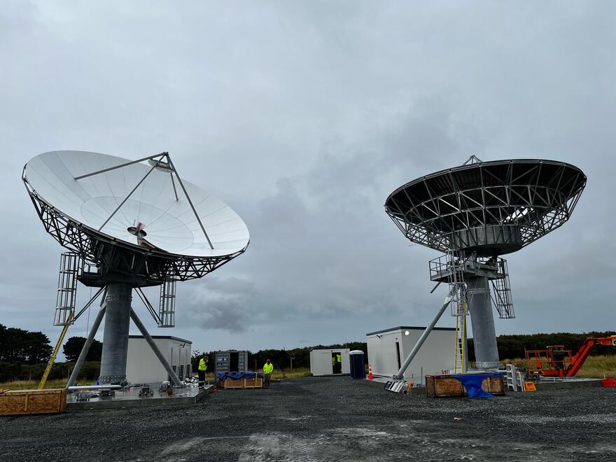
SouthPAN Milestone: Two 11-Metre Dishes Installed.
A significant milestone has been achieved in the construction of the uplink and ground control centre for the Southern Positioning Augmentation Network (SouthPAN), with the installation of two 11-metre satellite dishes at Awarua, Southland.
The Awarua centre is part of a collaborative effort between the New Zealand and Australian Governments to enhance satellite-based navigation systems. The first of its kind, opened in Uralla, New South Wales, in December 2023.
This development promises to bring at least six high-tech jobs to Southland upon the completion of the Awarua centre, expected by mid-2024.
SouthPAN, an abbreviation for Southern Positioning Augmentation Network, operates as a satellite-based augmentation system (SBAS). It leverages both space-based and ground infrastructure to meticulously compare satellite data with precisely measured positions. This process enables the identification and rectification of positioning errors within global navigation satellite systems (GNSS) such as GPS.
The corrected data is then transmitted to geostationary satellites, disseminating throughout New Zealand, Australia, and their maritime zones.
One of the most compelling aspects of SouthPAN is its potential to dramatically enhance GPS accuracy. Current estimates suggest that this augmentation could reduce the margin of error from 5-10 meters down to as little as 10 centimeters. This precision is invaluable for businesses and industries reliant on accurate location data.
The new infrastructure also promises to bolster the availability of SouthPAN’s early open services, initiated in September 2022. By establishing two operational sites in New Zealand and Australia, the network aims to enhance overall resilience.
Moreover, the impact of SouthPAN extends beyond navigation improvements. Industries such as precision farming and construction stand to benefit significantly. For instance, virtual barriers made possible by SouthPAN can enhance safety measures for construction workers.
Forestry operations are already leveraging SouthPAN for tasks like inventory mapping, harvesting, and worker safety protocols. Similarly, crop sprayers have reported more precise aerial applications of fertilizers, thanks to SouthPAN’s accurate positioning data.
Looking ahead, SouthPAN is poised to revolutionize aviation safety. By 2028, when the network is expected to be fully operational, helicopters and planes will be able to navigate safely through adverse weather conditions, expanding their operational capacities.
SouthPAN stands as a testament to the collaborative efforts between Toitū Te Whenua Land Information New Zealand (LINZ) and Geoscience Australia. Economic projections suggest substantial benefits for New Zealand, estimated at $864 million over the next two decades.
As construction progresses and SouthPAN becomes fully operational, its impact on navigation, safety, and various industries is set to be profound, marking a significant technological advancement for the region.
Source: https://www.linz.govt.nz/news/2024-02/satellite-dishes-place-southpan-centre-takes-shape